Are Indiana & Kentucky Still in a Drought After Last Week’s Severe Weather?
It's no secret that both May and June held a dry spell for much of this area of the country, with so many farmers and gardeners alike praying for some precipitation. We finally got some in the form of some severe weather, but has this put an end to the drought-like conditions that we have been facing in our region?
Understanding the meaning of the term "Drought"
According to the National Weather Service, drought is defined as being, "a period of abnormally dry weather sufficiently prolonged for the lack of water to cause serious hydrologic imbalance in the affected area" - Glossary of Meteorology 1959
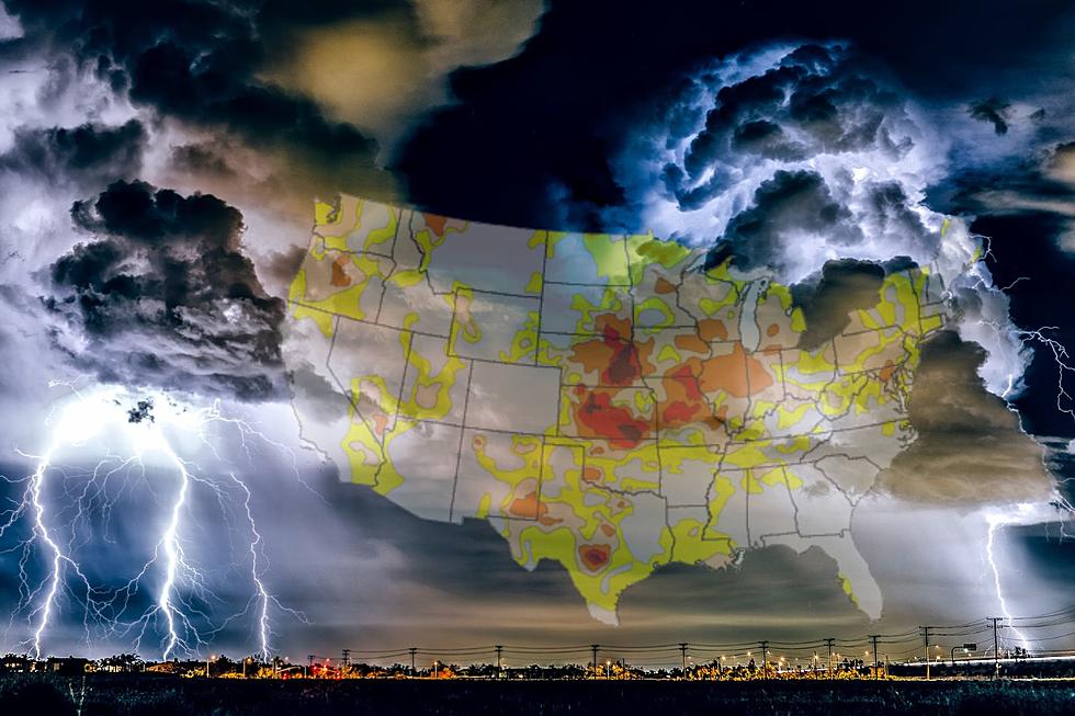
Droughts can be significantly impactful to the environment and humans. Water supplies become scarce, crops fail, and livestock and also negatively impacted. So where does the tristate stand on the drought monitor currently? Well, maps haven't changed much but take a look at what they are looking like here:


Drought conditions persist despite midweek storms
Despite the rainfall received this last week of June, across much of the Evansville area and Midwest we are still considered to be, for the majority, in some significant drought conditions.
The majority of Indiana (45.9% moderate drought and 33.6% in severe drought.) and Illinois (moderate drought 34.0% severe drought 57.6% and extreme drought 1.1%) are still under moderate to severe drought while Kentucky is fairing slightly better as much of the state is considered abnormally dry (39.9%) with some areas of moderate drought (22.6%)
Upcoming forecast
The heat is on for most of the country, as highs sore into the mid to upper 90s for the majority of the region and as the air quality is still being affected by the Canadian wildfires, being outside is anything but enjoyable. With extreme dewpoints and high humidity levels, this is not the weather for those suffering from chronic pulmonary issues or even just allergies and sinuses.
Much of the tristate is being affected by an excessive heat warning as we head into the Fourth of July weekend. We are all wondering if there is any more rain or a cool-down ahead of us anytime soon. Unfortunately with the calendar turning yet again into July, there isn't much to slow down this heat but, some more rain chances are coming up! Take a look at this forecast from the National Weather Service.

FORECAST
Scattered to numerous thunderstorms will develop this afternoon and continue early tonight. The afternoon storms will be most numerous over southeast Missouri and southwest Illinois, where isolated damaging winds and hail may accompany the storms.
The storms will develop eastward across western Kentucky and southwest Indiana by early tonight, as they begin to weaken. A few damaging wind gusts cannot be ruled out.
Heat indices will peak between 100 and 105 degrees today across southeast Missouri and parts of southern Illinois, prior to the
thunderstorms.
THURSDAY THRU TUESDAY
There is a chance of thunderstorms Thursday, with lightning and local downpours the main hazards.
A potentially more impactful round of thunderstorms is expected late Friday night through Saturday night. These storms may be organized into one or more complexes, capable of heavy rainfall and isolated severe wind gusts.
The chance of thunderstorms will begin to decrease Sunday, and especially Monday and Tuesday. The main hazards early next week will be lightning and local downpours.
Photos Of Wild Storm Clouds Over Evansville Area
Gallery Credit: Melissa
Amazing and Intriguing Weather Folklore
More From WGBF-FM


